Archaeological sites are some of Virginia’s most fragile resources. Threatened Sites grant funds offer emergency funding for archaeological sites endangered by erosion, impending development, or vandalism. Read on to learn about how this program has saved archaeological remnants at sites across Virginia and check out the four projects that are receiving funding this year.
The Virginia Department of Historic Resources (DHR) oversees a Threatened Sites Grant Program to assist in the recovery of archaeological data faced with imminent threat of destruction for which no other sources of funding exist. The program is currently funded with an annual budget of $50,000. These grant funds are often matched with donated time, materials, and travel expenses from members of the archaeological community who recognize the critical importance of these sites. There are hundreds of archaeological sites lost each year. For the first several decades of the program, these threats arose primarily from development in more populous areas of the state. More recently, we see dramatic losses from the effects of climate change, especially in our coastal and riverine areas.

Since the program’s inception in 1985, DHR has supported the scientific investigation of more than 138 sites, ranging from Native American camps over 15,000 years old to Civil War battlefields. The program has supported the rescue of hundreds of boxes of artifacts from dozens of sites, funded nearly 100 specialized analyses such as radiocarbon dating, and assisted with the production of over 25 reports, several of which were published in DHR’s publication series.
Archaeological sites are nonrenewable resources. Through well-crafted research, they assist us in expanding our understanding of the Commonwealth’s remarkably rich history. The Threatened Sites Program is a direct outgrowth of DHR’s mandates to conduct a program of archaeological research and encourage a statewide education program about our archaeological heritage. Since the program’s inception, DHR has established partnerships with the archaeological community, property owners, and local governments to do this work.


Each year, DHR considers proposals from the archaeological community for funding. A committee consisting of DHR staff and representatives from the Archeological Society of Virginia (ASV) and the Council of Virginia Archaeologists (COVA) meet to review and rank proposals and select projects for funding. Here are the projects receiving funding in 2024:
Laser Scanning Documentation of the Interior Portion of the Unfinished Western Canal Tunnel Portal (44BO0203) of the Marshall Tunnel Canal District
The Marshall Tunnel Canal District contains 13 features associated with an attempt to create a 1,900 ft canal tunnel through a mountain spur known as Timber Ridge. The tunnel was carved from three directions but ultimately left unfinished in 1856. The east end contains the longest section of tunnel (454 ft.) and the tunnelers’ working surface with features including barrow paths and footprints presumably from the 1850s. The west end of the tunnel still contains well-preserved tools, now submerged in standing water. The west end is also partially blocked by a cave-in; that blockage, combined with the fragile nature of the site makes its working surface inaccessible for traditional survey and documentation. Partnering with speleological technical and safety experts, staff from the Florida Public Archaeology Network and DHR will develop a method for documenting the western working face of the tunnel using laser scanning and photogrammetry. This will be done using a small inflatable boat that will be inserted into the area deflated, then inflated once inside the tunnel. Attaching the boat to a line that crosses the site should allow researchers to move the boat across the area without disturbing the super fine underwater sediments while gathering images of the entire area. The collected data will be processed to create a digital model of the tunnel’s western working face. This technique is experimental but has the potential to gather data that will eventually be lost in this fragile environment.
Magnetometry Survey of the Shelly Archaeological Site (44GL0318)
The Shelly archaeological site is one of 29 sites within the Shelly Archaeological District, which was listed on the National Register of Historic Places in 1990. Located on the York River, large portions of the site are actively eroding, and more site loss is expected with projected sea level rise in the Chesapeake watershed. In 2023, a Ground Penetrating Radar (GPR) survey on the site resulted in the identification of numerous potential features associated with indigenous occupation that were confirmed with sub-surface testing. A magnetometry survey will help identify features not typically identified with GPR, but that can be observed through the disturbance in the magnetic resonance in soils affected by factors such as fire and soil displacement. This work will identify priority areas to target for excavation before they are lost to erosion.
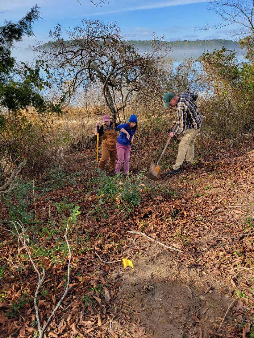
Radiocarbon Dating, Subsistence Column Analysis, and Additional Fieldwork in Support of the Evaluation and Oyster Shell Analysis of the Poropotank Island Site (44KQ0176)
Site 44KQ0176 is a Middle Woodland period (300-999 C.E.) shell midden and potential domestic site on an island in the Poropotank River. The island was once connected to the mainland but is now a single stand of trees surrounded by marsh under serious threat from rising sea level and cataclysmic weather events. In 2023, a survey was conducted to identify and evaluate the archaeological resources on the island which were previously known to the local community but undocumented archaeologically. The 2023 excavations identified a midden rich in subsistence evidence: oyster shell, animal bones and teeth, and botanicals (burned wood and food plants). Column samples were collected of this rich midden during these excavations, but their analysis was beyond the scope of the survey project. This project will support analysis of the subsistence column samples, radiocarbon dating to provide a chronology for the deposits and place them in broader settlement patterns for the area, a shoreline survey to identify the extent of eroding deposits, and additional limited excavations. The first phase of this project involved working with Tribal members in the field and producing interpretation for the tribes. This next phase will continue to engage with the tribes, both by receiving tribal guidance as well as providing additional field experiences to Tribal members.
Maritime Survey of Threatened Submerged Sites in the Pamunkey River
The ASV Maritime Heritage Chapter, in coordination with the DHR Underwater Archaeology program, will survey five areas of the Pamunkey River for submerged cultural resources. Documentation of numerous submerged resources within the Pamunkey river has been overlooked for decades and the river has become a hotspot for wreck and site looting. The proposed survey will use a sector scan sonar and a magnetometer to identify, assess, and capture images of submerged cultural resources. Most of the costs for personnel and equipment usage will be donated by ASV members and local business owners. While these sites are located on state-owned bottomlands, the Principal Investigators have spoken with neighboring property owners, including tribal representatives, and have their support for this project; their support is critical for the stewardship and protection of these fragile resources.
This article was submitted by Dr. Elizabeth Moore, DHR State Archaeologist, with much thanks to Randy Turner, retired DHR archaeologist, for sharing his knowledge of the Threatened Sites program.