Ask an Archaeologist: Points Collected in Isle of Wight County
Dear Mr. Clem,
My name is Rhodes D., and I am 9 years old.
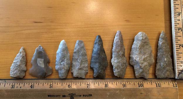
This is a picture of my grandfather's arrow heads. This year I'm studying Native Americans.
I would love it if you told me some information on these arrowheads. They were found in my great grandfather's farm fields in southern Isle of Wight County of Virginia.
Thank you. I appreciate it!
Sincerely,
Rhodes
Hi Rhodes,
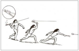
I was very happy to see your email and the photo. That is a good photo with the two rulers for scales. You have some nice points there. In fact, none of them are actually what we call “arrowheads,” but we do call them “projectile points.” We do so because they were more likely used as spear or atlatl points (see the the illustration). Arrows and bows were not used until long after these points were made. Arrowheads are also small triangular points about an inch or a little longer. They are only about 2,000 years old at the most and were used when Europeans arrived to Eastern North America in the 1600s. After European colonization, the arrow points were often made from metal that the native people got through trade with the colonists. The points you have are much bigger and much older than arrowheads. And the two two points shown on either end in the photo I can't identify because the bases of each appear to be missing.
The second one from the left is a Kirk Stemmed point. It is made from some good chalcedony material, a very fine-grained stone, and it is probably 8,000 years old or more! It is nicely made and was probably bigger at first but was re-sharpened, which wore it down, after being used over and over. That material is unusual for the area of southern Isle of Wight County, so it may have been carried from far away or traded with other people. It dates to the Early Archaic Period.
The other points look like mostly quartzite material, which is more common in that area of the county. The fifth from the left might be made from Normanskill Chert, but I’d have to see it in person to know for sure. They are all from the Late Archaic Period, except for the fourth one from the left. It is from the Middle Woodland Period and is the latest one you have and may be the closest in time to when arrows were adopted for use in the area of present-day Virginia. The Late Archaic is about 3,000 years to 4,500 years ago. The Middle Woodland is about 2,500 years to 1,100 years ago.
Below is a list of what I think you have. I have linked to the respective page on the DHR website that describes particular characteristics of each point. Keep in mind that some points may vary quite a lot in how they look from one example to the next within a given type but they have many of the same characteristics. For instance, not all Savannah River points will look quite the same, but they all will have curved sides and a concave base with moderate shoulders. Some points have been re-sharpened or heavily used so that they look a little different, which can make identification tricky.
Here is my list identifying your point (moving from left to right in your photo)
From left to right:
- Unidentified
- Kirk Stemmed
- Poplar Island
- Potts
- Bare Island
- Guilford (This link goes to a non-DHR webpage.)
- Savannah River
- Unidentified
Here are two web addresses that may be helpful to read:
- For understanding time periods and looking up what an atlatl is, visit this DHR webpage.
- To see examples of various points and read descriptions, visit this DHR webpage.
By the way, if you are curious about the names of the points and the dates, let me explain. Over many decades of research, archaeologists have found projectile points of all kinds in many places around the country. They decided they had to create a system to track the different types, because when we find points we compare them with what we know about other point types and decide what type they most resemble.
In the past, when the field of archaeology was new, people began to discover lots of different point types that had not been seen before. Often they named them after a local stream, the farm where they were found, a town, or maybe someone’s name. After a while they started trying to figure out how old each type was. When artifacts are found in a buried site we consider that good “provenience.” That means it was dropped or placed in a spot and has not been moved prior to an archaeologist uncovering it.
If other artifacts are found with the point, then we can assume that point and those other artifacts are from the same time period. This led archaeologists to begin collecting wood samples, charcoal, or bone that they found with the points and they then had those items analyzed using a system called radiocarbon testing. I won’t go into detail about that fascinating process (you can read about Radiocarbon dating in Wikipedia). It’s enough to say that radiocarbon testing can give a researcher a good set of dates for when the artifacts were left behind. When researchers tests samples from a number of sites with the same kinds of point type in it and the dates are all similar, then they can assume the point was made and used sometime during those dates. After many different researchers do this we can settle on a definite set of dates for each point type.
I hope this explains how we name and know what the point type is and how old it is.
Thanks for contacting me.
–Mike Clem
Eastern Region Archaeologist, DHR


